 |
|
|
FAQsThis page contains questions asked by users that have been answered by our application engineers. We always welcome suggestions. If you have any information you think would be of general interest, we'd like to hear from you. For the answer to your specific question on satellite-based navigational technology, please e-mail our Customer Support Department at support@NovAtel.com. NovAtel Products Questions
NovAtel's GPS receivers are easily upgradeable without returning your receiver to the factory. Our unique field-upgradeable feature allows you buy the equipment that you need today, and upgrade them without facing obsolescence. When you are ready to upgrade from one model to another, call 1-800-NOVATEL to speak with our Customer Service/Sales Personnel, who can provide a code that unlocks the additional features of your GPS receiver. This procedure can be performed at your work-site and takes only a few minutes.
The MiLLennium receiver is NovAtel Inc.'s previous generation receiver and is not recommended for new designs. Our OEM4-G2 and OEM4-G2L are hardware compatible with the MiLLennium and boasts improved Multipath rejection performance, higher data rates, and lower power consumption.
NovAtel's SPAN Technology GPS/INS system allows the user a more autonomous solution with periods of no GPS. All output is provided by the IMU, allowing for higher output rates (100Hz) than normal standalone GPS (typically 20Hz). IMU's have the benefit of being basically autonomous, allowing for short durations without any kind of updates. The major drawback of IMU's is the time dependent error propagation. This can be kept "in check" by means of GPS position updates and zero velocity updates. (ZUPTS). For more information, please refer to the SPAN Technology page.
The previous DL was based on our OEM3 product and used PCMCIA Flash Cards. The new Dl-4 is based on the OEM4 and uses Compact Flash (CF) cards. The DL-4 has an LCD, Keypad and associated user interface that allows field configuration and observation without an external controller. The DL had 3 blinking LEDs, and no keypad (just a power switch) and if you wanted to change something in the field you needed an external controller of some sort (laptop, handheld, etc.)
NovAtel's Pinwheel aperture coupled slot array technology is designed to operate at the GPS L1 and L2 frequencies. The receiving elements are coupled to filters and a low noise amplifier (LNA). Optimized to receive right-hand-circularly-polarized signals, its radiation pattern has been shaped to provide a uniform amplitude and phase pattern in azimuth plane and to reduce signal strength arriving near the horizon (low elevation angle). These features provide a very stable common phase center between L1 and L2 channels and decrease errors associated with Multipath and electromagnetic interference. For further information, please see the GPS-600 and GPS-700 Antenna product information on our web site.
NovAtel's patent pending Pulse Aperture Correlation (PAC) technology implements the latest digital signal processing techniques to provide superior tracking capability in the presence of multipath. PAC technology effectively doubles the pseudorange accuracy of the Narrow Correlator ® tracking technology and dramatically increases Multipath rejection characteristics by up to a factor of 8. PAC technology achieves this higher accuracy through a combination of low noise ranging measurements combined with a very narrow correlation window that dramatically reduces the effects of Multipath interference and distortion.
There are a lot of factors that can affect which receiver would be best for your application. NovAtel's products are designed for a variety of applications - and are flexible to meet your needs. Our Sales Staff are experienced in helping customers find the best product to suit their application, and can help you make the best decision regarding your GPS needs. Call 1-800-NOVATEL (668-2835) to find which product will provide the specifications you require for your next project. GPS Questions
Dual frequency GPS receivers offer two major advantages over single frequency equipment:
The first feature will improve differential GPS accuracy over long baselines (typically 10 kilometers or more). The effects of the ionosphere at two receivers located a short distance apart is essentially the same at each location. As a result, these errors are eliminated in the differential processing of the data. In fact, an "iono-free" L1/L2 solution (where ionospheric errors are reduced/eliminated using point #1 above) is often discouraged over short baseline observations since combining the data from each frequency will introduce extra noise into the solution that exceeds any ionospheric errors that are eliminated in the process. As the baseline distance between receivers increases, this correlation weakens and the ionospheric errors can become very significant. This happens because the atmosphere that the GPS signal passes through is different at each respective station. By taking measurements on two frequencies, the different effects of the ionosphere on the GPS signal at each station can be modeled, and the errors reduced. This allows for more accurate baseline measurements over long distances. The second feature, OTF technology, is useful for kinematic surveys and can provide rapid-static capabilities. In order to provide geodetic level accuracy (1-3 cm), the GPS receiver must be able to resolve the cycle ambiguities of the carrier frequency. With conventional single frequency receivers, this process can take anywhere from 30 to 60 minutes depending upon many factors, not the least of which is the length of the baseline. Dual frequency equipment allows for an operation called wide-laning which can significantly reduce the amount of time required for ambiguity resolution. Static surveys can be carried out much faster in a "rapid-static" mode where station occupation times are, again, significantly reduced. In addition, in the event of loss of satellite lock in the middle of a kinematic survey, carrier ambiguities can be solved while in motion or "On-The-Fly". In general, dual frequency GPS receivers will provide a faster, more accurate, and more reliable solution than single frequency equipment. They do, however, cost significantly more to purchase, thus it is important for potential GPS buyers to carefully consider their current and future needs. Assessment of a Non-Dedicated GPS Receiver System For Precise Airborne Attitude Determination A Differential Global Positioning System for Flight Inspection of Radio Navigation Aids A Kinematic Carrier Phase Tracking System for High Precision Trajectory Determination DGNSS Positioning Techniques for Flight Inspection Performance of Category IIIB Automatic Landings Using C/A Code Tracking Differential GPS Precise Aircraft-to-Aircraft Positioning Using a Multiple Receiver Configuration. Flight Evaluation of a Basic C/A Code Differential GPS for Category 1 Precision Approach.
When using a stand-alone receiver for navigation, will SA degrade velocity and direction information to the same extent as position (i.e. 40-100m)? Selective availability (SA) consists of intentional biases or errors placed in the GPS signal by the United States Department of Defense. These errors can be mitigated by applying differential processing techniques. It is not possible, however, to avoid the impact of SA on stand-alone receivers, and a position accuracy of plus or minus 40 to 100 meters must be accepted as long as SA is "ON". Velocity vectors (speed and direction) are affected by SA also, but because these calculations involve a difference operation between successive satellite measurement epochs, the error is reduced. As a result you can expect velocity accuracy approaching plus or minus 0.25 m/s, 0.6 mph, or 0.5 knots assuming phase measurement capability and a relatively high measurement rate (i.e. 1 Hz or better) by the GPS receiver. Direction accuracy is derived as a function of the vehicle speed. A simple approach would be to assume a worst case 0.25 m/s cross-track velocity that would yield a direction error function something like: d (speed) = tan-1(0.25/speed) For example, if you are flying in an airplane at a speed of 120 knots, or 62 m/s, the approximate directional error will be: tan-1(0.25/62) = 0.23 degrees Another example applicable to hiking would be to consider an average walking speed of 3 knots or 1.5 m/s. Using the same error function yields a direction error of about 9.5 degrees. It is obvious, then, that a faster vehicle speed will allow for a more accurate heading indication. As the vehicle slows down, the velocity information will become less and less accurate. If the vehicle is stopped, a GPS receiver will still indicate some kind of movement at speeds between 0 and 0.5 m/s in random and changing directions. This is a direct result of SA and represents the random variation of the static position. In a navigation capacity, the velocity information provided by your GPS receiver will be as or more accurate than that indicated by conventional instruments as long as the vehicle is moving at a reasonable rate of speed. It is important to set the GPS measurement rate fast enough to keep up with all major changes of the vehicle's speed and direction. It is important to keep in mind that although the velocity vector is quite accurate in terms of heading and speed, the actual track of the vehicle might be skewed or offset from the true track by plus or minus 0 to 100 meters as per the standard positional error caused by SA.
My brother thinks one ought to be able to obtain a highly accurate measure of one's position (x, y, z) using one GPS receiver. I am a surveyor and told him that it was not possible-but I couldn't explain to him why. Can you? There are two questions that rise from this issue. What is the definition of highly accurate, and what is the definition of one receiver? According to classic GPS theory, one civilian receiver operating in single point mode (no assistance from other sources) will have an accuracy of ±20 to 30 meters horizontally. This allows hikers and recreational users to place themselves on a map with some degree of certainty, but in terms of surveying, this is not considered accurate. Logging data and averaging for 24 hours may yield results in the order of 1 to 5 meters horizontally. Since several errors effecting the signal transmission will be nearly the same for two receivers near each other on the ground, a receiver at a point with known coordinates (a base) can monitor the errors and generate corrections for the remote receiver to use. This method is called Differential GPS, and is used by surveyors to obtain millimeter accuracy. There are some variations on this method which can easily be perceived as using only one receiver. For example, the US Coast Guard operates a differential correction service which broadcasts GPS differential corrections over marine radio beacons. As a user, all that is needed is a marine beacon receiver and one GPS receiver to achieve positioning accuracy of 1 to 5 meters. In this instance, the Coast Guard owns and operates the base receiver at known coordinates. Other examples of users appearing to use only one GPS receiver include FM radio station correction services, privately owned radio transmitters, and corrections carried by communication satellites. Some of the radio receivers have built-in GPS receivers and combined antennas, so they even appear to look as one self-contained unit. The major factors degrading GPS signals which can be removed or reduced with differential methods are the atmosphere, ionosphere, satellite orbit errors, and satellite clock errors. Some errors which are not removed include receiver noise and multipath. Another way to use only one receiver and achieve 1 to 5 meter accuracy is to use precise orbit and clock files. These two files are compiled by an elaborate network of GPS receivers around the world all monitoring the satellite characteristics. The data is processed to produce two files, one correcting the satellite clock and one correcting the satellite orbit parameters. Since there is extensive processing involved, these files are available on a delayed schedule. Files are available today to correct GPS data which was collected a few days ago. All the user needs is one GPS receiver and a computer to process on, and no differential radio is required. The US military has a way of using only one receiver to improve positioning to 10 to 15 meters. It uses the Precise Positioning Service (PPS). It is a military-only system, so civilians do not have access to this technology. Civilians use the Standard Positioning Service (SPS). Given these different methods and viewpoints, there are many different deductions possible. Each GPS method has distinct advantages and disadvantages, and only the general principals behind them have been covered here. Before attempting to decide which receiver and method is best for a certain application, it is best to consult someone in the GPS field to ensure the performance delivered is best suited for the accuracy required.
GPS satellite prediction software allows users of the NAVSTAR GPS constellation of satellites to view relevant information about these satellites. This information typically consists of:
This type of software generally requires a GPS almanac file. An almanac file contains information about the satellites including their position and motion with respect to time. This file is obtained from the satellites and does change. So it is advisable to use the most current almanac file which is available. The user then enters parameters to simulate the working environment including:
It is important to know how many satellites are visible as a minimum of four satellites are needed to obtain a good GPS position. It is also important to know the configuration of the satellites (DOP) as this will have a bearing on the positioning accuracy. Prior to the full deployment of the GPS constellation (24 satellites), there were occasions where receivers could not track enough satellites to obtain a good position. Today, with the full constellation having been deployed, there should be a minimum of at least four satellites visible at all times anywhere in the world. Unless there are obstruction (buildings, mountains, trees, .etc.) which block the view of the sky. Planning software can anticipate possible problems including obstructions and shows the best times to perform field work.
Your imagination is the only limitation to the possibilities of what GPS can be used for. GPS systems are very versatile and can be found in almost any industry. It can be used to map forests, help farmers harvest their fields, navigate airplanes on the ground and above, in military applications, and used by emergency crews to locate people in need of assistance. GPS is working in many places that we are not always aware of. GPS applications generally fall into 5 major categories:
Some of the applications that GPS is currently being used for around the world include mining, aviation, surveying, agriculture, marine and military. These days doctors, scientists, farmers, soldiers, pilots, surveyors, hikers, emergency crews, delivery drivers, sailors, fishermen, dispatchers, computer programmers, lumberjacks, fire-fighters, and people from many other walks of life are using GPS in ways that make their work more productive, safer, and often easier.
Why is it recommended not to use low elevation satellites? A low elevation satellite is a satellite which your GPS receiver is tracking that is "just" above the horizon. Generally, a satellite which is considered low elevation is anywhere between the horizon and up to 15 degrees above the horizon. This satellite is usually just setting or just rising. There is generally nothing wrong with the data that is being transmitted by these satellites. In fact, the data is the same as a high elevation satellite or a satellite right above you. However, the path that the GPS signal has to take from the satellite to your receiver is different. The signal from low elevation satellites has to go through more atmosphere and the atmosphere it has to go through is usually "thicker". This is important as we always assume that your GPS signal behaves like a typical electro-magnetic signal and travels at the speed of light in a vacuum. All calculations including computing your position is based on this assumption and the fact that the speed at which a GPS signal travels in air is almost the same as it travels in a vacuum. Thus, if the signal is going through more atmosphere and does not travel the same in this "thicker" atmosphere as in a vacuum (or air) then our position calculation is going to be more inaccurate. Also, as the satellite signal has to go through more atmosphere, it is generally noisier and is not as clean. This will again effect how good the data is. Most GPS receivers have a default of anywhere between 5 to 15 degrees set as an "elevation mask" or "cut-off". This value is used so that satellites below the mask or cut-off are not used in computing position. Thus, noisy low elevation satellite data is not used. For users who post-process data, it is best to collect all data (even below the mask). Thus, when post-processing, you will have all data available and can experiment at what mask you can use to provide the best results. Usually, the default value is fine. However, in cases where there are not enough satellites visible, a low elevation satellite may actually help in providing a useful solution.
What is the impact on the accuracy of differential GPS when the base station and the roving GPS receiver(s) are separated by large distances? For this discussion, we will assume that when we talk about large distance, we are referring to distances greater than 1000 kilometers (600 miles). Typically, for this type of baseline length only code data is used in a differential GPS system. Carrier-phase data is typically used for distances much shorter than 1000 kilometers. (The advantage of using carrier-phase data, to produce centimeter-level accuracies, is greatly reduced when large distances are involved.) GPS operates in a similar fashion as conventional surveying tools such as electronic distance measuring instruments (EDM's). This means that there is a constant and a proportional error associated with computed positions. The proportional error will depend on the distance the base and rover receivers are apart. Therefore, the larger the distance, the lower the accuracy. We also have to take in account the quality of the data being received. Better receivers generally provide cleaner signals and thus better accuracy. When operating in differential GPS mode, you require at least four common satellites at the base and rover. The number of common satellites being tracked at large distances is less than at short distances. This is important because the accuracy of GPS and DGPS positions depend a great deal on how many satellites are being used in the solution (redundancy) and the geometry of the satellites being used (DOP). DOP stands for dilution of precision and refers to the geometry of the satellites. A good DOP occurs when the satellites being tracked and used are evenly distributed throughout the sky. A bad DOP occurs when the satellites being tracked and used are not evenly distributed throughout the sky, i.e., they are grouped together in one part of the sky. Also, the principal of DGPS positioning assumes that there are common errors at the base and rover stations. These errors include: atmospheric errors, satellite clock and ephemeris errors, and selective availability (SA). Typically, in a differential GPS survey, a receiver occupies a survey control marker at a known location referred to as the base station. The base station collects GPS data and computes a position. This position is then compared against the published coordinates. The difference between these two positions in the way of range errors to the satellites are your differential corrections. Usually, these corrections are then passed to your rover unit(s) for use in computing the rover's differentially corrected positions. However, the further apart the base and rover receivers are, the less their errors are in common. Thus, the differential corrections computed at your base are less applicable at your rover's location at large distances.
As newer satellites are launched, will they improve the accuracy of GPS? Assuming that newly launched satellites are similar (provide the same information) to the existing satellites, the accuracy of GPS will improve to a certain extent when newer satellites are launched. As newer satellites are launched, more satellites will be available and you will be able to track more of them. Thus, you will be able to obtain lower DOP values (see FAQ on "What is the impact on DGPS by long baselines?" for more details). This DOP value is very important as it is directly related to the positioning accuracy. There has also been discussions about future GPS satellites having additional capabilities such as the ability to transmit data on a third frequency. Current GPS satellites transmit data on two frequencies, L1 and L2. These changes will benefit the GPS users through increasing the achievable accuracy of the system.
What is the real accuracy of the Coast Guard's DGPS as compared to the commercial DGPS? The Coast Guard claims a 10 meter accuracy for their DGPS. Some commercial DGPS vendors seem to have and offering for 5 meter (or better) accuracy. Are the commercial vendors really supplying something more accurate than Coast Guard signal? The real accuracy of the Coast Guard's DGPS signal is more than likely better than 10 meters. However, there a number of factors which are involved in determining the accuracy of a DGPS system. These include:
If you were to compare the Coast Guard and commercial DGPS services under the same situations, e.g., base-user proximity of 1.0 kilometer and stated accuracy at 2drms (95% confidence), you would probably find that the Coast Guard's DGPS is at least equivalent to, if not better than, commercial DGPS services. Also of note is that the Coast Guard's DPGS service is available to all users (marine, land and air), similar to a public utility without any charge. In addition, the Coast Guard's service acts as an integrity monitor, which provides an independent check of each GPS satellite's signal and reports whether it is good or bad. Commercial DGPS vendors usually have a monthly or yearly subscription fee. All of the previous discussions have been dealing with code data. Some commercial DGPS services are now also starting to provide high accuracy carrier-phase data along with code data. With this type of data, depending on your equipment, you will be able to achieve decimeter and even centimeter level accuracies.
I have a GPS plus computer to record data at a fixed location, and another GPS plus laptop in the field also recording data as I travel. Can I take the difference between the recorded location and the known location of the fixed point and use that as an error correction for the recorded data in the field? Would this reduce the problem of SA and get more accurate data? The simple answer to the question is YES. You can take the difference between recorded position and known location and apply this, as a position correction, to your field data (mobile station). However, the correct and more standard way of computing this correction is to compute the range error to each GPS satellite being tracked at your fixed location and to apply these range corrections to the observations at your mobile station. The position corrections method is seldom used in industry. The drawback of this method is that computed corrections will vary depending on the location of the fixed station. The geometry between the fixed station and the tracked satellites is not accounted for. Also, position corrections at the fixed site are computed with a certain group of satellites while the mobile station is tracking a different group of satellites. In general, when the position correction method is used, the farther the fixed and mobile stations are apart, The range corrections method is more commonly used in industry. The advantage of using this method is that it will provide consistent range corrections and hence field positions regardless of the location of your fixed station. You will only be able to obtain a "good" differential position if both the fixed and mobile stations are tracking at minimum the same four satellites. Selective Availability (SA) refers to the United States Department of Defense intentionally degrading the positioning accuracy attainable by GPS to 100 meters horizontally (2drms) and 156 meters vertically (2 sigma). They accomplish this by intentionally dithering the satellite's clock parameters and degrading the satellite's ephemeris information. A way to counter the effects of SA is by differential GPS positioning (DGPS). DGPS refers to using one base receiver at a known location and one or more rover receivers at unknown locations. As the position of the base receiver is accurately known, we can determine the extent of the error that is present in GPS at any given instant. This can be performed by either of the two methods previously described. Not only do we counter the effects of SA, but we also counter the effects of a number of biases present in GPS including; ionospheric and tropospheric errors, ephemeris errors, and receiver and satellite clock errors. Both the position correction and range correction methods are valid and would significantly reduce the effects of SA. A user could choose either method depending on the application and the accuracy required.
How does the GPS determine what Magnetic North is? Do the satellites transmit a database, or some kind of lookup chart to determine the declination for your given lat/long? And, how accurate is it? Magnetic North refers to the location of the Earth's Magnetic North Pole. Its position is constantly changing in various cycles over centuries, years, and days. These rates of change vary and are not well understood. However, we are able to monitor these changes. True North refers to the earth's celestial pole, i.e., at 90° north latitude or the location where the lines of longitude converge. This position is always the same and does not vary. The locations of these two poles do not coincide. Thus, a relationship is required between these two values for users to relate GPS bearings to their compass bearings. This value is called the magnetic variation correction or declination. GPS does not determine where Magnetic North is nor do the satellites provide magnetic correction or declination values. However, some GPS receivers store this information internally in lookup tables so that when users specify they want to navigate with respect to Magnetic North, this internal information is used. These values are also available from various information sources such as the United States Geological Survey (USGS). The USGS produces maps and have software which enable users to determine these correction values. By identifying your location (latitude and longitude), you can obtain the correction value. Contact USGS at (303)273-8475 for more information on their products.
How long do I need to sit on a 10 km baseline? How long you need to occupy stations for a 10 km baseline depends on the system you are using and what type of accuracies you require. There are three major categories we can look at:
The term "optimal conditions" refers to observing six or more healthy satellites being tracked with a geometric dilution of precision - GDOP value of less than 5 and relatively low multi-path. Note: the above situations apply to both real-time and post-processed solutions with minor differences.
Are your receivers compatible with others on the market? All GPS receivers output two solutions: position and time. The manner in which they output makes each receiver unique. Most geodetic and survey grade receivers output the position in electronic form (typically RS-232), which makes them compatible with most computers and data loggers. All NovAtel receivers have this ability. However, each manufacturer has a unique way of formatting the messages. A NovAtel receiver is not directly compatible with a Trimble or an Ashtech receiver (which are also incompatible with each other) unless everyone uses a generic data format. Fortunately for the user, there are several generic data formats available. For position and navigation output there is the NMEA format, real-time differential corrections use RTCM or RTCA format, and receiver code and phase data use RINEX format. NovAtel and all other major manufacturers support these formats and can work together using them. The user must understand his or her post-processing and real-time software requirements. Good software will support a generic standard; bad software will lock the user into one brand of GPS equipment. For the most flexibility, insist on generic data format support for all hardware and software solutions.
Questions concerning GPS are generally about two key issues: accuracy and reliability. When a GPS position is computed, there are four unknowns being solved: latitude, longitude, height and receiver clock offset (often just called time). The solutions for each of the four unknowns are correlated to satellite positions in a complex way. Since satellites are above the antenna (none are below it) there is a geometric bias. Therefore geometric biases are present in the solutions and affect the computation of height. These biases are called DOPs (Dilution Of Precision). Smaller biases are indicated by low DOP values. VDOP (Vertical DOP) pertains to height. Most of the time, VDOP is higher than HDOP (Horizontal DOP) and TDOP (Time DOP). Therefore, of the four unknowns, height is the most difficult to solve. Many GPS receivers output the SD's (Standard Deviations) of the latitude, longitude and height. Height will often have a larger value than the other two. Accuracy is based on statistics, reliability is measured in percent. When a receiver says that it can measure height to one meter, this is an accuracy. Usually this is a one sigma value (one SD). A one sigma value for height has a reliability of 68%. In other words, the error is less than one meter 68% of the time. For a more realistic accuracy, double the one sigma value (one meter) and the result is 95% reliability (error is less than two meters 95% of the time). Generally, GPS heights are 1.5 times poorer than horizontal positions.
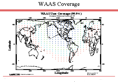
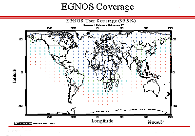
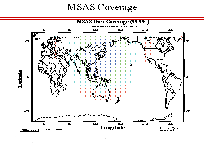
User Coverage Plots Percentage of time at least N satellites are visible with the following characteristics:
Switching assumes use of data form primary SBAS. Combination assumes that reference data from all SBASs are available to form user connections.
OEM4 API Questions
The Application Program Interface (API) allows you to develop specialized C/C++ applications to further extend the functionality of your OEM4 family receiver. By using the functions provided by the API, along with the commands and logs already provided by the OEM4, a wide variety of applications can be created.
. Support for multiple tasks, with varying priority levels.
Please contact NovAtel Customer support.
Only one application can be executed. If user applications are loaded in multiple data blocks, one in the higher data block will always be executed. (2 highest to 7 lowest)
The application is initially run in its own task separate from the rest of the system. In addition to the application's main task, more tasks can be created (up to 17 total) with each having different priorities.
No, only two tasks can have PRIORITY_LEVEL0 (highest), all other priority levels can be shared.
Depending on what position type, number of channels tracking, and measurement rate being used, there is about 50% to 75% of the CPU available.
Not all API features and functionalities are available in OEM4-G2L due to its physical limitation. The OEM4-G2L does not have a 100-pin expansion slot and special features such as I2C, Compact Flash File System, and extra GPIOs are not available.
There are 4 NVM data blocks available. Each block has the size of 2000 bytes.
API supports 3 external ports and the 2 internal virtual ports. There are 3 external ports available on OEM4-G2 and 2 ports for OEM4-G2L.
It allows the application to interface to the GPS receiver through the same interface (commands and logs) as an external controller would through a physical com port.
No, the USB port cannot be accessed from your application since the API does not currently provide an interface for this like it does for the serial ports. Developing your personal drivers will have no effect on this. Currently, the USB port is solely used by the GPS application.
1 MB code and 3 MB run time data (Firmware Version 2.200 or up will allow for more, up to at least 4MBytes).
The compiler for ARM processors should include support for a variety of ARM processors including the StrongARM 1100
(on the OEM4) and the XScale PXA255 (which is on the OEM4-G2). It is suggested compiling for the StrongARM 1100 which
is code compatible to the PXA255.
Currently, we only support Green Hills MULTI.* http://www.ghs.com/products/MULTI_IDE.html
*The compiler compatibility has been tested up to Green Hills Multi V4.0.5. You must run OEM4 firmware version 2.300 or higher.
Yes, It supports CAN bus and there are two CAN ports available.
Yes, it supports I2C interface. (Only on OEM4-G2 HW revision 3.02 or above)
** This feature requires additional hardware which will make use of the 100 pin expansion slot on the OEM4-G2 board. NovAtel does not provide the hardware. For more detail, please contact NovAtel Customer Support.
Yes, the suite of functions in the CompactFlash file system enables the user to access an MS-DOS file system through a familiar POSIX-like interface. (Only on OEM4-G2 HW revision 3.02 or above) With the OEM4 CompactFlash file system, the user is able to: . Open and close files ** This feature requires additional hardware which will make use of the 100 pin expansion slot on the OEM4-G2 board. NovAtel does not provide the hardware. For more detail, please contact NovAtel Customer Support.
Email: support@novatel.ca
Please contact NovAtel Customer support.
Email: support@novatel.ca
No. currently only static memory allocation is supported.
It tells the linker what addresses to put all the ELF sections at. For the user app, we start at address 0 and let everything follow in sequence. At runtime, this gets remapped dynamically.
Only SanDisk Compact Flash cards are supported by NovAtel API.
The API uses a FAT16 system and it supports up to 2 GB.
The PCMCIA timings that are programmed into the OEM4 firmware are based off of specs in the SanDisk Compact Flash specification document. It is possible that other brand media has different chip timings than we use and it may not work. Navigating our Web Site
Product specifications can be found listed under each product in the accompanying PDF file format. Technical specifications can also be found in the product manuals located in the Product section of the web site.
Contact Sales for product pricing information by phone at 1-800-NovAtel (U.S. and Canada) or at 1-403-295-4500 or by email at sales@novatel.ca.
A listing of registered NovAtel Inc. dealers can be found under the Products heading on our web site. For a direct link to this page, click here.
Product manuals can be found under the Documentation Updates section of the website. Most of these documents are quite large and we recommend downloading them to your own computer before opening them for best viewing. Download time will vary depending on the speed of your connection and size of the file. NovAtel Inc. scans all documents for viruses, but we do advise you to take extra precautions when downloading anything from an unfamiliar web site. Should you have problems downloading from our web site, please contact NovAtel Inc. via email at webmaster@NovAtel.ca.
With Adobe Acrobat's free .PDF viewing software (Acrobat Reader), which is available for download from here.
Product updates can also be found under the Firmware/Software Updates section of the web site. Download time will vary depending on the speed of your connection and size of the file. NovAtel Inc. scans all documents for viruses, but we do advise you to take extra precautions when downloading anything from an unfamiliar web site. Should you have problems downloading from our web site, please contact NovAtel Inc. via email at webmaster@NovAtel.ca. |