 |
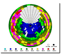
Multipath Assessment Tool / MEDLLNovAtel Inc. has recently implemented a Multipath Meter (MPM) feature within the Multipath Estimation Delay Lock Loop (MEDLL®) portion of Wide Area Augmentation System (WAAS) type receivers. The MPM outputs data which describes the multipath environment that an antenna is experiencing. It uses NovAtel's MEDLL technology that is able to model and remove multipath signals from the direct signal.The MPM calculates the amplitude, delay and phase of the multipath on each satellite signal currently being tracked and outputs them in standard NovAtel log format along with the residuals from the process. This data is tracked every second. The Multipath Assessment Tool (MAT) is PC software which allows the user to assess the multipath environment in a graphical manner. MAT automatically extracts multipath parameters from the MPM such as: relative multipath power, delay and phase. Other parameters such as C/No, elevation and azimuth angles which effect multipath are also extracted from the receiver, . These parameters are displayed by MAT in a graphic manner with various types of plots to simplify the multipath analysis. The plots are updated as the output is received from the MPM. This allows the user to view the multipath environment as the satellites are passing overhead. The capability to playback MPM data is also available during post processing for a more detailed analysis. If you don't already have a WAAS/MEDLL receiver, one can be leased for the duration of your multipath site survey. Features
RF and MultipathGPS signals are susceptible to reflection because of the short wavelength at L1 frequency. As GPS is a radio navigation ranging system, the direct path signal is of primary interest and the reflected signal causes biases to the ranging measurements. Multipath is the greatest source of errors to system operation in single differencing mode. Multipath errors cannot be reduced by traditional DGPS signal differencing techniques. Therefore careful site selection for a reference receiver or survey point is essential. Advantages
|
||||||||||


